
Parker Street Directory Walkthrough
A useful street directory begins with a normalized address, not a guess about a household. Check the number, spelling, unit or lot, city label, and ZIP as separate clues. A Parker mailing address can fall outside the incorporated Town, so the Douglas Assessor supplies the parcel and legal-description anchor while the Clerk and Recorder supplies the recorded chain. GIS supplies map context. Voter products, permits, and old address directories add dated evidence under separate access rules.
- Normalize the address. Start with the Douglas Assessor basic search in Address, City, and Zip Code mode. Try the street string, note a unit or duplicate result, and sort by Best Match, Account, Owner, or Address.
- Capture the parcel identity. Save the account, SPN, owner, mailing, situs or location, legal description, subdivision or lot, tax district, and result date. Mailing and situs can differ.
- Check the map. Identify the target and adjacent parcels in the Douglas Real Property map. Turn on ZIP, zoning, tax, subdivision, and municipal-boundary layers, then compare Town GIS address, lot, annexation, and street layers.
- Follow the deed chain. The recorder does not index street addresses. Take the Assessor owner and legal description to LandmarkWeb, search the party, lot, block, subdivision, Book and Page, or reception number, and inspect the image.
- Add resident clues with care. A lawful voter report, permit row, or historical reverse directory may connect a name to an address at a stated time. Keep its role and date; do not treat one result as a complete household list.
The evidence chain is address to parcel, parcel to legal description, legal description to recorded party, and dated household clues where an official or library source supplies them. That is more useful for property history, family research, and civic questions than a loose name list.
Parker Street Records
Different Parker records answer different street questions. The Assessor shows owner, mailing, parcel keys, sales, and characteristics. LandmarkWeb shows parties, document type, reception, legal description, Book and Page, and images when available. GIS places parcels beside neighbors and boundaries. A permit archive places a public event at an address. None alone proves occupancy.
| Record Set | Keeper | Street-Level Use | Access and Caution |
|---|---|---|---|
| Assessor parcel roll | Douglas County Assessor | Owner, mailing, situs, account, SPN, legal description, sales | Basic and advanced online search; owner data is not occupant proof |
| Real Property map | Douglas County GIS | Parcel geometry, adjacent parcels, ZIP, zoning, tax and boundary layers | Public dynamic viewer; verify map facts in the Assessor or Recorder |
| Town GIS layers | Town of Parker | Address points, lots, subdivisions, annexations, streets, HOAs and Town boundary | Public map and downloads; layer dates and disclaimers vary |
| Recorded documents | Clerk and Recorder | Grantor, grantee, deed type, reception, legal description and images | LandmarkWeb is free online; street addresses are not indexed |
| Permit archive | Town of Parker | Applicant, address, subdivision, status, description, valuation and unit count | Useful for dated work history; applicant is not an occupant |
| Voter products | Douglas Elections and Colorado SOS | Public registration address and name fields when lawfully released | Request products exclude protected fields; no public street browser |
| Tax account inquiry | Douglas County Treasurer | Current and prior tax history, receipts and mailing verification | Dynamic portal; tax account is not a household list |
| Reverse directories | DCL, DPL and archives | Historical address-to-occupant, owner, or business associations | Householder path begins generally in 1924; Parker volume remains a gap |
Use the account or SPN to keep layers together. If an address returns several parcels, compare legal description, subdivision, lot, unit, map polygon, and reception date. A record can be accurate in its own role and still answer a different question.
- Parcel
- A mapped property unit with an Assessor account and SPN. One street can contain several parcels or units.
- Situs address
- The physical location tied to a parcel. It can differ from the owner's mailing address.
- Plat
- A recorded map that lays out lots, blocks, streets, or easements for a subdivision or land division.
- Criss-cross directory
- A historical reverse directory arranged by address, often linking a place to an owner, resident, or business.
Parker Assessor Street Search
The Douglas Assessor has a basic address lead and an advanced street-segment search. Basic modes include All, Address, City and Zip Code, Owner Name, Account Number, and SPN, with sorting by Best Match, Account, Owner, or Address. The advanced Address tab accepts street-number ranges, Street Name typeahead, Cities, and ZipCode. Results, Map, Download, Clear Form, and the Property Ownership and Location Report selector support a repeatable review.
| Search Mode | Fields and Controls |
|---|---|
| Basic | All or Search All Fields; Address, City, and Zip Code; Owner Name; Account Number; State Parcel Number; one free-text field; Search; Best Match, Account, Owner, Address sorting |
| Advanced Account | Account number; State Parcel Number minimum and maximum; Account Type; Appraisal Type; Owner Name; Property Value minimum and maximum; Neighborhood; Neighborhood Extension; LEA |
| Advanced Building | Square Footage; Style or Built As; Quality; Building Use; Year Built; Basement Square Feet; Finished Basement; Walk-Out Basement |
| Advanced Sales | Sale Price; Sale Date; Recording Number; Deed Type; Grantor; Grantee; Vacant or Improved; Multi-Parcel; Qualified Sale |
| Subdivision | Subdivision Name; Filing Description; Block; Lot; Tract; Recording Number |
| Tax Authority | Tax District typeahead; Tax Authority |
| Advanced Address | Street Number minimum and maximum; Street Name typeahead; Cities; ZipCode |
| Land | Township; Section; Range; Land Use; Land Attribute; Acres minimum and maximum |
The result card can expose account, SPN, owner and mailing, legal description, subdivision, lot or PLSS, tax district, values, characteristics, and sales or recording data. The Assessor says ownership follows a recorded deed and boundaries can update after a deed, survey, or plat. Record the search date.
The Douglas County Assessor advanced search shows the filters that make a Parker street review more precise.
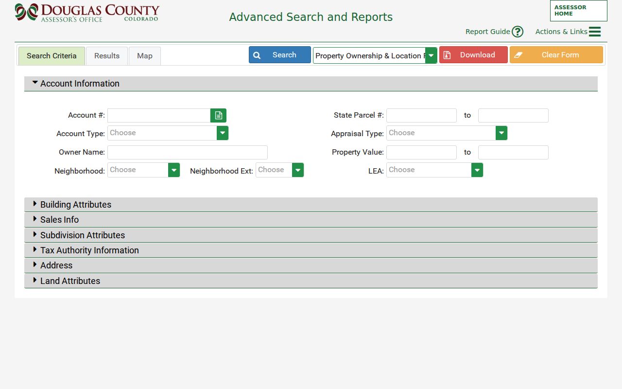
These filters separate a street segment into parcel records without suggesting that a public search returns a complete household roster.
Parker Street Map Layers
A map identify is a geography tool. Open the Douglas Real Property viewer, identify the target and adjacent parcels, and preserve the map date, layer names, map ID or account, and street context. Layers include parcel, ZIP, zoning, tax, subdivision, municipal-boundary, flood, and street data. Dynamic widget labels, buffer controls, and result samples were not located, so do not promise a radius or bulk resident export.
Town GIS adds address points, lots, subdivisions, annexations, HOAs, land use, floodplains, facilities, trails, and the Town boundary. Stonegate, the Pinery, Villages of Parker, Cottonwood, Newlin Crossing, Looking Glass, Tannterra, Trails at Crowfoot, and Kime Ranch are geography clues, not proof of one association or a person's connection.
The Douglas County residential property maps describe the viewer and its layer family for a parcel-first street search.
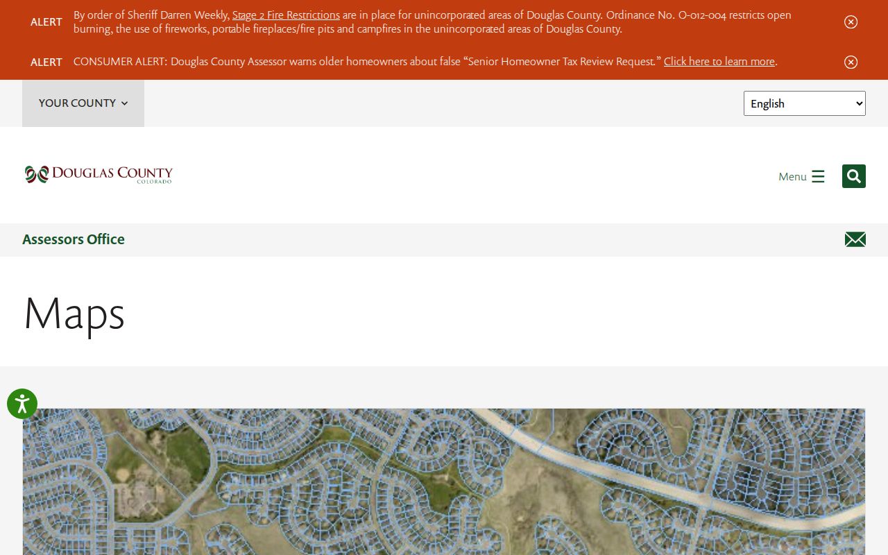
Use the map to choose parcels, then return to the Assessor and Recorder for owner, legal, and document facts. A visible line is a lead, not the source record.
Note: A parcel, ZIP, situs address, and municipal boundary can overlap on a map without sharing the same legal meaning.
Parker Deeds By Address
The Recorder route turns a street lead into a deed-history path. LandmarkWeb does not index street addresses, so copy the Assessor legal description and carry the current owner or party name into the search. Use name, lot, block, subdivision, Book and Page, reception or instrument number, document type, or a date window. For an unknown name, begin with last name only. A one-to-five-year window is more useful than an open-ended search.
Retain Grantor and Grantee, deed type, reception, date, consideration when shown, legal description, Book and Page, cross-references, and image status. Search the current owner's purchase deed, then search the seller as a prior grantee while the legal description matches. A deed transfers an interest; it does not state that the grantee occupied the address.
Douglas County announced on June 16, 2026 that a multiyear effort indexed and uploaded land records back to 1866, with 3,877,662 unique public records searchable. LandmarkWeb still warns about non-indexed historical documents and wrong book, page, or reception values. Read the digitization announcement with LandmarkWeb; older work may need a Recorder station or microfilm.
The free Recording Activity Notification can alert selected personal or business name variations to a document type, recording time, and document link. It does not replace a deed search.
Parker Permit History
The Town permit archive adds a different address history. Visible columns include issued date, permit number, type, subtype, applicant, subdivision, status, address, address-point record, unit count, description, and valuation. Rows tied to Newlin Crossing, Looking Glass, Tannterra, Trails at Crowfoot, and Kime Ranch can date a public construction or alteration record. Use address and subdivision together.
An applicant may be an owner, builder, contractor, company, or another party. A permit dates work without establishing first construction, occupancy, or completion. Town archive and public-notice searches can add planning packets and minutes, while GIS can bridge an older place label to streets, lots, subdivisions, annexations, and boundaries.
When a permit and parcel disagree, compare account, SPN, legal description, subdivision, address point, applicant role, and date. A targeted CORA request can seek a public permit or map layer that is not posted, but cannot open protected household, utility, or voter information.
Note: Permit history is strongest for documenting public work at a place, not for naming every household connected with it.
Parker Reverse Directory Trail
Historical reverse or criss-cross directories are the street directory layer current property systems cannot replace. Denver Public Library describes city directories from 1873 and householder directories from 1924 as municipality, county, year, resident, business, and address routes. The reviewed catalog did not locate a Parker-specific digitized volume or exact year, so the index is a route, not proof that every Parker street appears in every run.
For one address, build an era ledger with source, year, old street or rural label, person or business, role, page or image, and next source. Pair the entry with a deed, census, newspaper, obituary, cemetery, marriage, or probate record. A directory is annual and selective; it can use a rural route or list a business.
Denver Public Library's research index supplies directory, householder, property, newspaper, cemetery, obituary, and Sanborn paths. Douglas County Libraries can bridge maps, photographs, oral histories, and county documents. Request a named collection, place, year, or prior owner.
Parker ZIP Boundary Check
Parker's postal geography can make a street directory look more exact than it is. Town sources say USPS assigned Parker addresses to ZIP Codes 80134 and 80138 before the 1981 incorporation. Both postal areas extend beyond Town boundaries into unincorporated Douglas or Elbert County. Record ZIP, Town boundary, parcel situs, and legal description separately.
The Douglas ZIP map and Real Property viewer show spatial context, while Town GIS boundary and annexation layers help answer whether a parcel is inside the Town. If labels conflict, call the Town or Assessor and retain the answer date. Use parcel and legal description for recorded work.
Boundary check. A Parker ZIP identifies a postal delivery area. It does not by itself establish Town jurisdiction, municipal services, voter district, or the custodian for every record.
When ZIP is the main key, the Parker ZIP code directory keeps postal and municipal layers distinct.
Parker Street Directory Limits
A street directory cannot show every person connected with an address. The Assessor owner may be a company, trust, estate, or a person whose mailing address is elsewhere. A deed party may have sold, held a lien, or acted for an entity. A voter address is a registration record, not a household list, and protected voters may be excluded. A permit applicant is a work-record contact. Library entries are historical.
Private utility lists, delivery records, DMV data, sealed or juvenile court records, protected vital details, and other restricted fields are not street-directory layers. The Driver's Privacy Protection Act limits DMV information. Colorado confidentiality programs can provide a substitute address or suppress a voter record. A failed search can reflect a boundary mismatch, input error, moved record, redaction, or incomplete index.
Lawful use. Parker records are available for personal, lawful research within each custodian's rules. Do not use an address or name record to stalk, harass, intimidate, or harm anyone.
Keep only needed fields, cite the custodian and date, and ask about correction or statutory redaction when a public record is wrong. A refusal is an access result, not an invitation to seek a less accountable source.
Parker Records Desk
Online search is only one channel. Douglas Assessor and Recorder research stations are at 301 Wilcox Street in Castle Rock, Monday through Friday from 8 to 5. The Assessor is 303-660-7450, Recording is 303-660-7446, the Clerk is 303-660-7469, and the Treasurer is 303-660-7455. Copy routes include counter, mail, express delivery, email, and LandmarkWeb downloads.
- County online: use the Assessor, Real Property GIS, LandmarkWeb, and Treasurer inquiry.
- Town sources: use Parker GIS, permit and public archives, boundary layers, and targeted CORA requests.
- Historical help: ask DCL, DPL, or Colorado State Archives for a named map, directory, newspaper, or deed collection.
- Copies: printed recording copies are $0.25 per page, certification is $1 per document, and shipping depends on page count.
CORA is the Colorado Open Records Act, C.R.S. 24-72-201 et seq. State guidance presumes three working days, extendable up to seven for extenuating circumstances. Parker pages also state three business days and up to ten, so confirm the current policy and quote.
Note: A complete Parker street directory entry should carry the address key, parcel or legal key, source role, date, and access limit together.